

Are you dreaming of exploring Pictured Rocks National Lakeshore in Upper Peninsula Michigan but unsure how to see it by foot? In this post, I’ll give you the best and must-hike trails that will take you to the most breathtaking scenery this park has to offer. From otherworldly sand dunes to rushing waterfalls, from pristine beaches to staggering rock formations and cliffs – Pictured Rocks has it all! And what better way to see it than by exploring with your own two feet?! It’s a hiker’s and adventurer’s paradise and it’s waiting for you to uncover her treasures.
ᑭIᑕTᑌᖇEᗪ ᖇOᑕKᔕ ᑭOIᑎTᔕ Oᖴ IᑎTEᖇEᔕT:
- Grand Sable Dunes
- Sable Falls
- Sable Beach
- Chapel Falls
- Chapel Rock
- Grand Portal Point
- Indianhead
- Mosquito Beach
- Mosquito Falls
- Spray Falls
- Miner’s Castle & Beach
- Miner’s Falls

DISCLOSURE:
THIS POST CONTAINS AFFILIATE LINKS AND I RECEIVE A COMMISSION IF YOU VISIT A LINK AND BUY SOMETHING ON MY RECOMMENDATION. PURCHASING VIA AN AFFILIATE LINK DOESN’T COST YOU ANY EXTRA, AND I ONLY RECOMMEND PRODUCTS AND SERVICES I TRUST. ALL OPINIONS ARE MY OWN. FOR MORE DETAILS SEE MY DISCLOSURE AND PRIVACY POLICY.
What to bring on your hikes in Pictured Rocks (especially the longer ones):

Backcountry.com is currently having a BIG Memorial Day Sale – some of the items below are up to 50% off! Plus, they’re also offering 20% off one full-price item.
The North Face Hydra 26L Backpack
- Lightweight and breathable
- Durable and quick-drying
- Self-equalizing load lifters
- Accommodates tools, snacks, extra layers, and hydration system

Columbia 100MW Titanium Outdry Hiking Boot – Women’s
- durable protection for rugged trails
- breathes and blocks moisture to keep feet dry
- high rebound midsole offers comfort & energy return
- industry-leading traction
- provides ankle support and a secure fit

Hydro Flask 24oz Standard Mouth Water Bottle
- Highly durable stainless steel
- TempShield protected
- Keeps water cold up to 24 hrs.
- Sweat-free design

Platypus Big Zip EVO Reservoir
- clean and quick flow
- self-sealing bit valve
- leak-proof shutoff valve
- easy to fill
- silver-ion treatment protects water from mold & bacteria

Adventure Medical Mountain Series Medical Kit
- ideal for single day in the woods
- suitable for two hikers/backpackers

- practical and precise
- mirror ensures accuracy and enables signaling
- includes a detachable snap-lock lanyard and whistle

- multiple LEDs and settings
- tiltable housing for your perfect angle
- stormproof
- easily adjustable

- slim, durable and powerful portable charger
- cables included for on-the-go charging
- 3-4 charges for phones

- soft, smooth and absorbent microfiber blend
- Polygiene odor-control
- lightweight and compact

Don’t forget to pack extra layers (such as a windbreaker and/or raincoat) and, of course, snacks! It’s also wise to always bring along a multi-tool, bug spray and sunscreen and even some weatherproof matches (in case of emergencies). Okay, let’s go! …
How to see Pictured Rocks by foot…
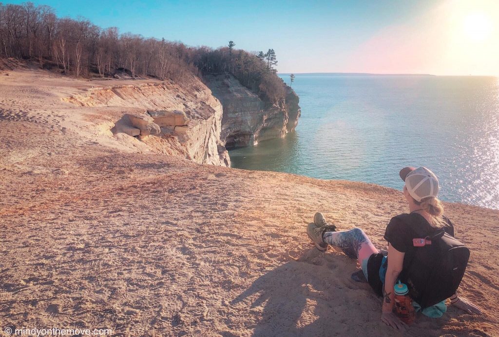
Grand Sable Dunes


Trailhead: Dune Trail begins at the west end of Sable Falls Parking Area (46.6668696, -86.0133177)
Distance: 0.7 miles round-trip
Difficulty: Easy (except for scrambling up the dunes at the end).
Note: bring sunglasses as it’s very bright (when the sun is out).
The highlights of this hike:
The views from atop the Grand Sable Dunes are seriously unmatched. Your eyes can stretch as far as the horizon, overlooking the sparkling Lake Superior as you’re surrounded by pine forests and rolling dunes. Personally, I had never seen a mountain of sand so high that it’s above the trees and oversees a massive GREAT Lake 300 feet below. Talk about the perfect place to watch the sun set!
How to see Pictured Rocks by foot…
Sable Falls and Sable Beach

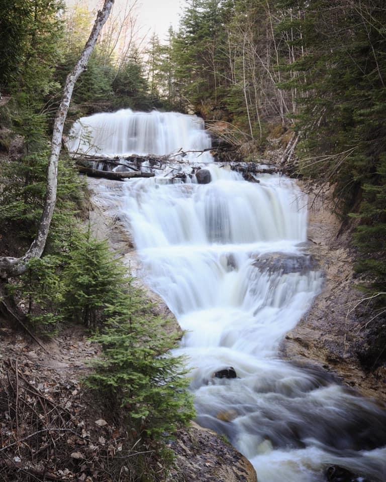


Trailhead: Sable Falls Trail begins at Sable Falls Parking Area (same coordinates as above).
Distance: 0.25 miles down 200+ stairs to to reach the falls. Continue down the trail a tiny bit further, after the falls, to reach the beach (about another 0.1 miles). Roundtrip (to the beach and back) the hike is approximately a total of 0.7-0.8 miles. If you prefer to walk down the beach a little, you must cross a little stream leading into the lake. You can either wade through it and get a little wet or cross via the log jam like we did (be careful with this option).
Difficulty: easy – moderate (the stairs make it more difficult for some).
Note: bring a towel in case you get wet crossing the creek or in case you decide to take a dip in the lake.
The highlights of this hike:
Sable Falls is a beautiful, three-tiered waterfall cutting its way through the forest and running down to greet Lake Superior. The beach, at the bottom, rests at the base of Grand Sable Dunes. Thus, providing a different perspective of these beasts as you stand below them and admire their towering heights. Even more, the beach is full of the most brilliantly colored rocks and pebbles I’ve ever encountered and has some very cool sand designs (as photo’d above in the 4th slide).
How to see Pictured Rocks by foot…
Chapel Basin Loop Trail
(My favorite in Pictured Rocks National Lakeshore!)
Trailhead: Chapel Basin Parking Lot (46.5195550, -86.4618199).
Distance: ~10.6 miles to hike the full loop.
Difficulty: moderate-difficult (the excessive mud and fallen trees create many obstacles).
Notes and tips: It’s a poorly marked trail so be sure to bring a map. If you don’t have a physical map, you can take a photo of the map with your phone at the beginning of the trail (just be sure your phone doesn’t die!). It’s also a good idea to download a google map of the area for offline use.
The highlights of this hike:
Chapel Falls
- This is the first point of interest you’ll arrive to after about 1.2 miles of hiking (if you begin by heading east on the loop).
- This is one of the wilder waterfalls in Pictured Rocks National Lakeshore because it requires a further hike and, as a result, is much more secluded. It slides 60 feet down Chapel Basin and has picturesque views on the farther side. The first side you come to allows you to walk up close to the top of the falls (take caution when doing this).


Chapel Rock
- 1.9 miles past Chapel Falls (3.1 miles into your entire hike), you come to one of the coolest rock formations in the park known as Chapel Rock. The rock sports a giant window-looking hole and a single tree perched on top. It’s quite the unique sight, showing off mother nature’s creativity without doubt!
- Even more, below Chapel Rock rests the most gorgeous little beach which boasts a dazzling waterfall flowing into the turquoise great lake. The whole scene looks straight out of a storybook!
- There are backcountry campsites nearby, as well – making it the most ideal spot to spend an entire evening and/or morning. I can’t wait to go back and swim there (I didn’t get near enough time with her my first go-around). However, I certainly took advantage of this prime spot by wading in the falls and splashing about the cool waters as we took a little break.
For more on backpacking and camping in the backcountry of the park, check out Travellenial's Guide here.


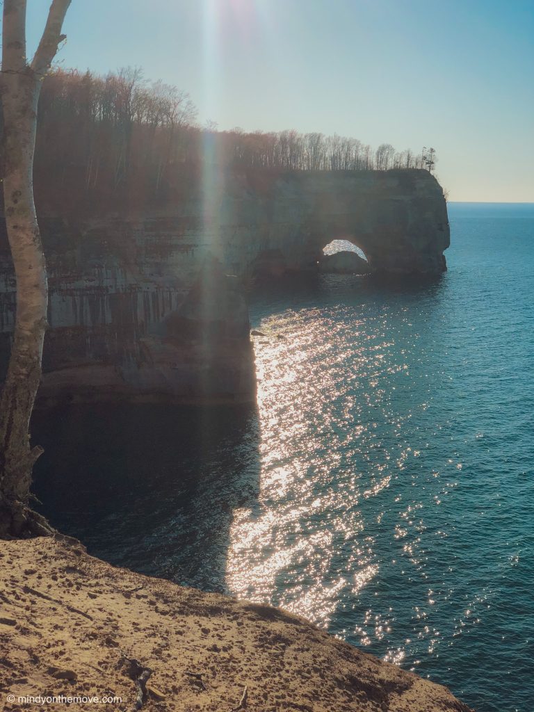
Grand Portal Point
- Journeying along the coast for another 1.7 miles, you’ll reach your next destination: Grand Portal Point.
- You can see Grand Portal for miles along the coastline before reaching it (the giant rock outcrop with a portal for boats and kayakers, etc, to pass through below on the lake).
- However, once you reach Grand Portal Point, you’re able to walk out on her and witness the most jaw-dropping views in the entire park! At least for me, it was the best view and I couldn’t comprehend what I was seeing. I kept asking myself “is this real?!” and kept commenting “I feel like I’m on the edge of the world“.
- In short: this place transported and transfixed me.
- Tip: the golden hues and sun set are utterly unreal to watch here. However, it doesn’t make for good photo opportunities because you’ll be shooting directly into the sun.
- Swipe through the photo slideshow below to see its views!

Indianhead
(Not a politically correct name, I know. Unfortunately, I obviously didn’t have a say in naming it and so it stands incorrectly, still).
- It’s a beautiful and very elongated cliff with a rock formation at the end that is said to resemble a “Native American head”.
- Native Americans came here from many regions to trade goods and metals on Grand Island. Therefore, this special rock is a place to pay homage and has been a place of legend and lore for many years.
- Personal Opinion: I can’t see the face. Then again, we didn’t view it from in front via the water *shrug*. It’s gorgeous, nonetheless!

Mosquito Beach & Mosquito Falls
- These are the last two points of interest along the loop trail.
- Mosquito Beach is approximately 1.5 miles past Indianhead and Mosquito Falls is another 1.5 miles further (3.0 miles from Indianhead).
- We walked swiftly by these sights due to the impending darkness. We spent too much of our day enjoying the other sights and didn’t leave enough time for the last couple. I’m happy we chose to hike east first, though, because those were my favorite stops by far!
After Mosquito Falls, you have about one more mile to your finish line!
Chapel Basin Loop Summary:
I truly hope you enjoy this hike as much as I did! Though not the easiest or shortest hike, it’s absolutely 1000% worth every ounce of expended energy. Chapel Basin Loop Trail is now, hands down, my favorite hike east of the Mississippi!
How to see Pictured Rocks by foot…
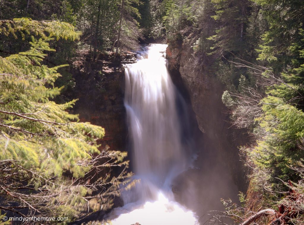
Spray Falls

Trailhead: This hike is a detour off of Chapel Basin Loop trail. At Chapel Rock, you take the trail heading east (away from Chapel Beach) for 1.7 miles. At 1.7 miles, you’ll arrive to the top of the falls where there’s an incredible view of the Pictured Rocks coastline (heavenly place for a lunch break). You can also marvel at the natural infinity pool created here with the stream running off the massive cliff into Lake Superior far below. Walk another 0.4 miles east to witness the falls jetting off the cliffside (above photo).
To read about an alternative route to Spray Falls (and more about Spray Falls in general), check out GoWaterfalling's post here.
Distance: Out and back, round-trip, this trail adds another 4.2 miles onto your 10.6 mile Chapel Basin Loop hike.
Difficulty: Same as Chapel Basin Loop trail, above.
The hightlights of this hike:
This detour trail takes you further down Michigan’s Upper Peninsula coastline and offers a plethora of scenic views, including but not limited to: Spray Falls itself. Personally, I could never grow tired of seeing her insanely awesome scenery and, hence, why we opted to take this adventure on (regardless of the added miles). And, second to Grand Portal Point overlook, the overlook at Spray Falls is one of the greatest in the park!
Peep a couple of my video clips below to see that infinity pool effect I previously mentioned along with the views from the top of the falls where we ate our lunch.
How to see Pictured Rocks by foot…
Miner’s Castle and Beach


Trailhead: As neither of these are exactly hiking trails per se (more or less just easy, breezy walking here and there), you can access the rock formation and beach via their respective parking lots: castle parking area (46.4932963, -86.5499958) and the beach parking area (46.4956268, -86.5417867).
Distance: Less than 0.2 miles down some steps to the lower overlook of the castle formation (up close) and even less than that to just view it from the upper overlook.
To the beach, it’s about a short 400-foot jaunt from the parking area through the little wooded area to the sandy shore. From there, it’s up to you how far you’d like to roam the beach area and beyond!
Diffulty: Easiest
The highlights of this hike:
The neatest part about seeing this rock formation from land is the contrast of the water colors: bright green to bright blue. It’s hard to see why it got its name from land, but from the lake you’re able to see its castle likeness seamlessly.
The beach is a truly unique gem with it’s rust-colored river running out of the forest and through the sand, finally reaching its destination: Lake Superior. The juxtaposition is wild! I enjoyed wandering across the beach, through the forest and even to the little “Elliot Falls“.

Check out TripAdvisor to see some of the best things to do near Pictured Rocks National Lakeshore.
How to see Pictured Rocks by foot…
Miners Falls


Trailhead: The fall’s parking lot (46.4740545, -86.5427134).
Distance: 1.2 miles (round-trip).
Difficulty: Easy
The highlights of this hike:
Miners Falls is the pinnacle of this hike with it’s sheer force (the most powerful waterfall in the park) and 50-foot drop. However, the trail itself lends its hikers to a serene forest saunter as it weaves through the forested basin adorned with wildflowers and birdsong.
Check out the surreal Autumn colors along Pictured Rocks National Lakeshore at Jess Wandering's post: The Stories Behind Your Favorite Photos (it's number 9).
Bonus: Where to stay when visiting Pictured Rocks?
On any typical adventure such as this, you could find my husband and I camping in the far off woods. But, thanks to Covid-19, the campgrounds and campsites were closed during our visit and the park was only open for day use and hiking. Therefore, we opted for our second favorite lodging option:
Airbnb

We stayed in a one bedroom cottage at Au Train Lake, about 15 minutes from Munising, Michigan and 20 minutes from the start of the park.
- Super friendly and helpful hosts who never came in contact with us (respectful of Covid-19 standards).
- Extremely clean cabin
- Has a yard with a fire pit
- You can see the lake from the yard
- Has all the amenities you could possible need: full kitchen, bathroom with hot shower, bedroom with 2 beds (sleeps 3), a living area space and dining table.
- Wifi and a television are available and funcitional
- Prime location to Pictured Rocks National Lakeshore and other destinations in the Upper Peninsula area.
- There’s laundry on site as well as a convenience store and a place to purchase fire wood
- I highly recommend it!
To see some more of my AirBnb recommendations, check out my budding page:
All in all, our time hiking all over Pictured Rocks National Lakeshore in Michigan was unforgettable and utterly mesmerizing (to say the least). I’m obsessed with places that seamlessly transport you to another world and, something about the way her rugged land just dropped off into the still(ish) waters of the turquoise Great Lake, transported me to the edge of a fantasy world. But, it wasn’t a fantasy at all. Nope. Our earth is just pure magic and has these powerful and wondrous effects that I forever adore. This is a must-visit and must-hike place in the USA and deserves so much adoration – I can’t possibly sing its praises enough!
I’d love to hear from YOU!
Have you ventured to Pictured Rocks National Lakeshore yet? If not, what sight are you most looking forward to seeing? Would you love to backcountry camp here? And, if you have been here, please share one of your trip highlights/memories with me! I’d love to hear your stories and special moments. 🙂
Enjoy my “How to See Pictured Rocks by Foot” post?
Feel free to pin!


As always…
Thank you for reading and happy travels!
-Mindy
Check out a couple of my other favorite hikes and hiking stories below:


Goodness I keep hearing of such stunning hikes in Michigan; These all sound amazing, but the waterfalls are particularly stunning!